NW Scheduler can draw, or import from JW.org, your Master Territory Map Border. Afterwards, you can adjust how the map displays and save to file for physical printing (See km 8/00 p. 2).
Labels can be added, e.g. displaying your Congregation name or neighboring congregations. Optionally display the Kingdom Hall location and where all publishers live.
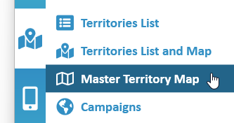
To access the Master Territory Map, click Territories > Master Territory Map
Master Territory Map View
The Master Territory Map view shows a Map of your Overall Territory boundary.
It can optionally show selected Territory Boundaries, the Kingdom Hall Location and where Publishers live.
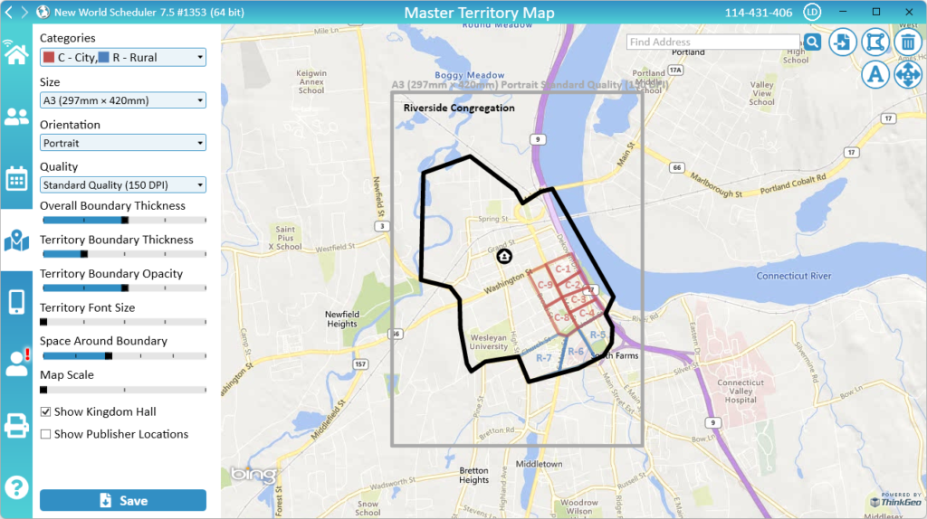
Overall Territory Boundary
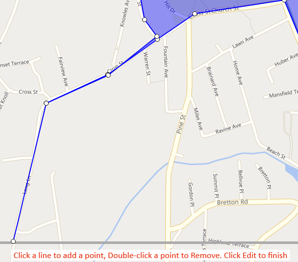
Draw or Edit Overall Territory Boundary
- Click Territories > Master Territory Map
- In the top-right, click Edit Overall Territory Boundary button
- Draw your Territory Boundary
- Click Edit Overall Territory Boundary button again
Import Overall Territory Boundary from JW.org
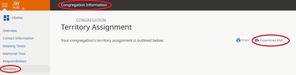
Download KML file from JW.org
- Login to JW.org
- Up the top, click Congregation
- Under Maintain Profile, click Contact Information
- Where it says “Use the Contact Information feature to add or change the Public Contact Telephone”, click the Contact Information link
- On the left, click Territory
- Click Download KML
- Save this file somewhere on your computer
Import KML file into NW Scheduler
- Click Territories > Master Territory Map
- In the top-right, click Import Overall Territory Boundary button
- Select the KML file you saved to your computer
- Click OK
Delete Overall Territory Boundary
- Click Territories > Master Territory Map
- In the top-right, click Delete Overall Territory Boundary button
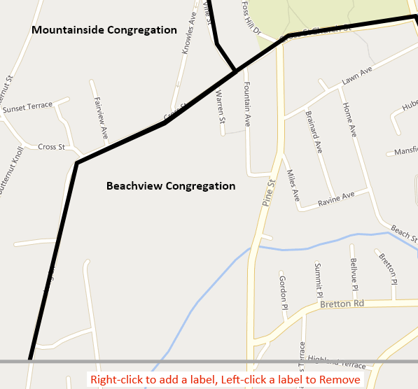
Labels
Labels can be added to the Master Territory Map. These will display when saved and printed. Each label can have its own size and color.
Add Label
- Click Territories > Master Territory Map
- In the top-right, click the Labels button
- Right-click anywhere on the map to add a label
- Enter the Label name, font size and color
- Click the Labels button again
Edit or Move Label
- You cannot edit or move labels. Simply remove the existing label and create a new one.
Remove Label
- Click Territories > Master Territory Map
- In the top-right, click the Labels button
- Left-click a Label to delete it
- Click the Labels button again
Kingdom Hall
The Kingdom Hall location can be shown on the Master Map. This can also be saved and printed.
Locate Kingdom Hall
- Note: If the Kingdom Hall has already been located (has Latitude and Longitude coordinates), this button will change to “Move Kingdom Hall”
- Click Territories > Master Territory Map
- In the top-right, click the Locate Kingdom Hall button
Move Kingdom Hall
- Note: If the Kingdom Hall has not yet been located (does not have Latitude and Longitude coordinates), this button will change to “Locate Kingdom Hall”
- Click Territories > Master Territory Map
- In the top-right, click the Move Kingdom Hall button
- Move the Kingdom Hall
- Click the Move Kingdom Hall button again
Save Master Territory Map
Saving the Master Territory Map allows you to have a digital copy of the Master Territory Map. This also can be used to print the Master Territory Map to display in your Kingdom Hall.
Click Save to save the Master Territory Map.
- Note: Depending on your Size and Quality settings, this may take a long time to process
The following options are available when saving:
Territory Categories
Which Territory Categories will be displayed on the Map and saved.
Size
The Paper Size to save. This can be:
- International sizes A2, A3, A4
- American sizes ANSI B, C, D or ASCI B, C, D
Orientation
The Paper Orientation, either Portrait or Landscape.
Quality
The Quality, either Standard (150 DPI) or High (300 DPI).
- Note: Standard Quality is usually used for displaying on computer monitors, whereas High Quality is usually used for large physical printing.
Overall Border Thickness
The thickness of the black, outside border.
Territory Boundary Thickness
The thickness of the internal Territory Category boundaries.
Territory Boundary Opacity
The opacity (or transparency) of the internal Territory Category boundaries.
Territory Font Size
The font size of the internal Territory Names.
Space Around Boundary
The space between your Overall Territory Boundary and the edge of the page.
Map Scale
The scale of the actual Map. This affects how it looks when saved and printed.
Show Kingdom Hall
Shows or hides the Kingdom Hall on the map.
Show Publisher Locations
Shows or hides where publishers live on the map.
This should not be used when printing the Master Map for the Kingdom Hall.
- Note: Publishers must have both the Latitude and Longitude values set to display on the map. See Person Information and use the Geolocate button to find these coordinates.
Show Neighbor Congregation Borders
It is not possible to show the entire Neighbor Congregation border on your Master Territory Map.
However, it is possible to add parts of their border.
- First Draw or Import your Overall Territory Boundary
- Edit the Overall Territory Boundary
- “Extend” your Territory Boundary to include any Neighboring Congregation borders.
- E.G. You can draw a “thin” shape that will display like a line.
- Optionally, add Territory Labels showing the Neighbor Congregation territory
Additional Help
- Territories Help
- Territories List
- Territories List and Map
- Territory Information
- Territory Addresses
- Territory Assignments
- Territory Map (Printed)
- Master Territory Map
- Territory Campaigns
- Territory Settings
- Letter Writing Maps
- Phone Witnessing Maps
- NW Publisher app Features – Territories
- Print Territory Reports and Territory Cards
- Import Territories, Addresses & Territory Assignment Records
- Common Territory Questions and Problems