The Territory Map allowed you to add an image or PDF to a territory. This will display on the printed Territory Card. It will also show on the NW Publisher app as a territory preview.
- Note: If you have added a Territory Boundary and will not physically print the Territory Card, there is no need to create or add a Territory Map.
Maps can be created either with NW Scheduler, Google Maps or any other software.
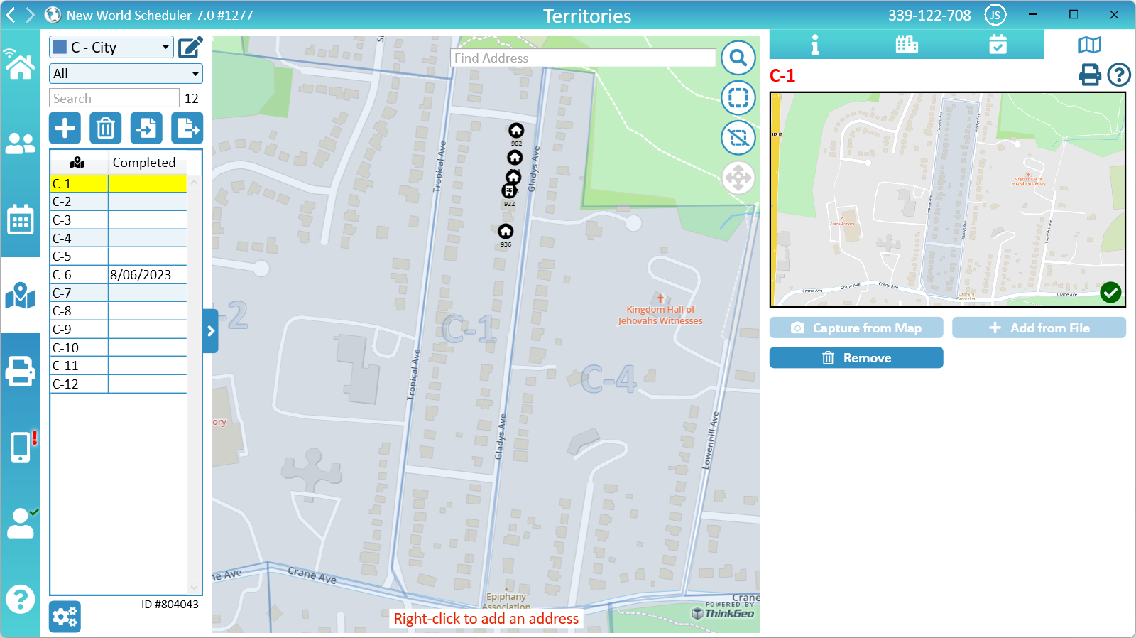
Capture from Map
- Note: If you have added a Territory Boundary and will not physically print the Territory Card, there is no need to create or add a Territory Map.
If you have created a Territory Boundary for this territory, it can be used to Capture from Map.
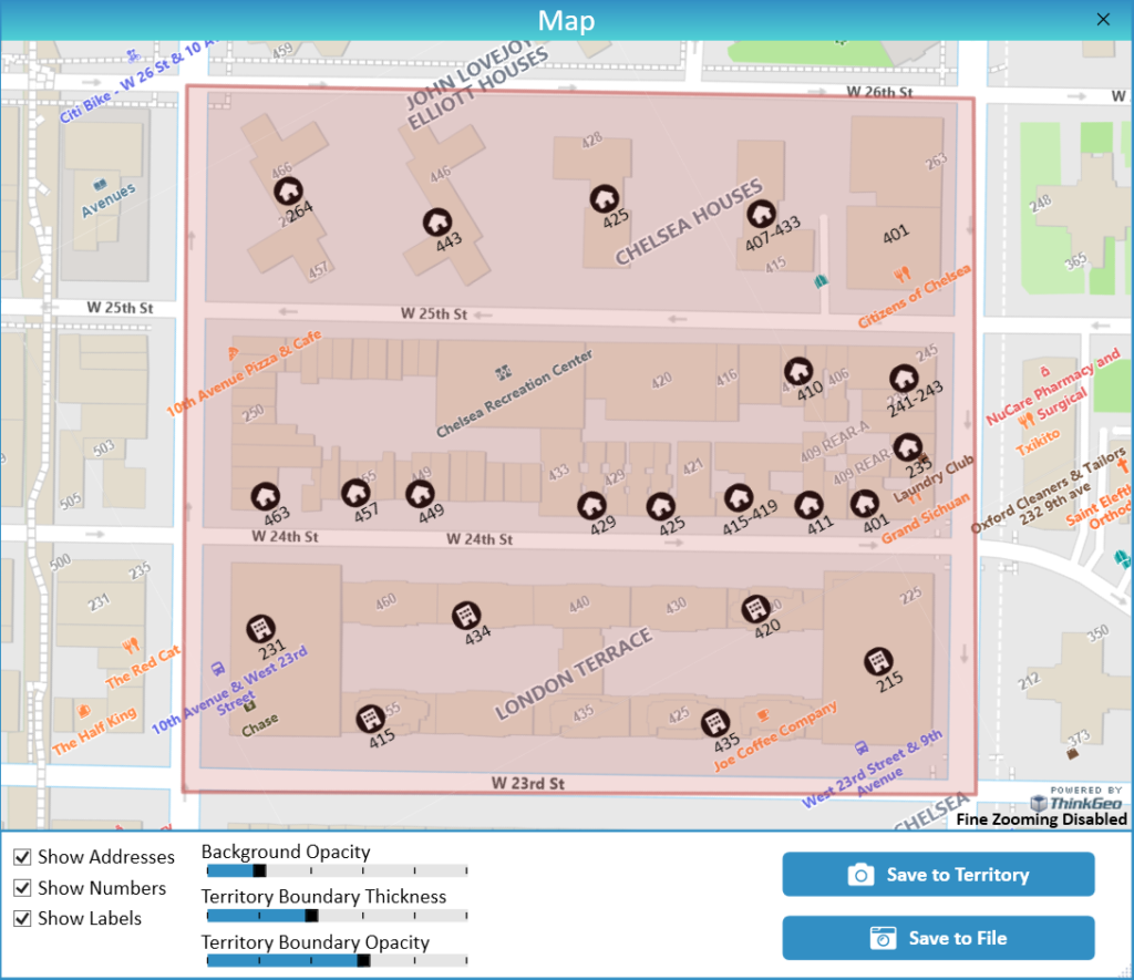
- Tip: If you hold down the ALT key and move your mouse, you can rotate the map, which might make it clearer for printing.
- Tip: The size of the window determins the size of the captured image, and therefore the size the map will be printed at. If you want the image to print larger, make the window size larger when capturing the map.
- Click Territories
- Select the territory
- Click Map
- Click Capture from Map
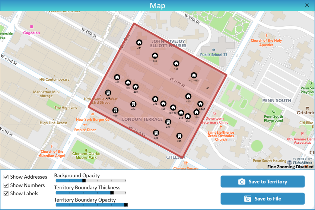
- Resize, Rotate, Pan and/or Zoom to the exact size and area you want to capture
- Optionally, tick Show Addresses to also include Territory Addresses on the map
- Optionally, tick Show Numbers to show the house numbers underneath the addresses
- Optionally, tick Show Labels to show any labels
- Optionally, adjust the Background Opacity, Boundary Thickness and Boundary Opacity
- Click either Save to Map or Save to File
- Note: Save to Map will save the image directly into NW Scheduler, whereas Save to File will save this image on your computer.
Default settings
Rotated, Zoomed and Opacity Adjusted
Add from File
- Note: If you have added a Territory Boundary and will not physically print the Territory Card, there is no need to create or add a Territory Map.
If you have not created a Territory Boundary for this territory, you will need to first be create the map using Google Maps or any other software, and then saved in either PNG, JPEG or PDF format.
- Note: We cannot offer any support on how to do this.
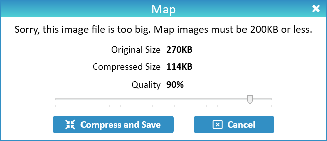
The map file size must be 300KB or less, as New World Scheduler does not support maps larger than 300KB.
If your map is an image (PNG or JPEG) and is larger than 300KB, New World Scheduler can automatically compress the image to under 300KB while you are adding it.
If your map is a PDF and is larger than 300KB, you must manually compress the file before adding. Please see Common Questions > How to compress a PDF
- Note: Congregation Sharing must be enabled to add a map.
- Click Territories
- Select the territory
- Click Map
- Click Add
- Select either a JPEG, PNG or PDF file on your computer
- Click OK
- Important: If the file size is 300KB or less, the map will be automatically added, otherwise the file must first be Compressed. NW Scheduler does not support maps larger than 300KB.
- For Image files: Select the appropriate Quality and click Compress and Save
- For PDF files: You must manually compress the file then add again. See Common Questions > How to compress a PDF
- Once a map has been added, you will see a small thumbnail. Double-click to see the full-size map.
Change Map
- Note: The map Images are simply image files, like screenshots. If you update the Territory Boundary, obviously these maps will not be updated and will need to be re-created.
Remove Map
- Click Congregation > Territories > Territories List
- Click Map
- Select the Territory you wish to delete
- Click Remove
Map Image Problems
- Click Open Map Folder to see the files
- If any file the same name is 0 KB or cannot be opened in File Explorer, delete that file
- Close and re-open NWS Desktop and the new map should be re-downloaded.
- If that doesnt work, simply remove the Map and then re-add the map, either by capturing from Map or adding from File.
Additional Help
- Territories Help
- Territories List
- Territories List and Map
- Territory Information
- Territory Addresses
- Territory Assignments
- Territory Map (Printed)
- Master Territory Map
- Territory Campaigns
- Territory Settings
- Letter Writing Maps
- Phone Witnessing Maps
- NW Publisher app Features – Territories
- Print Territory Reports and Territory Cards
- Import Territories, Addresses & Territory Assignment Records
- Common Territory Questions and Problems